| Introduction | Holiday Cottage | Location | Booking | Prices | Our region | Photo album |
| Choose your language here please |  |  |  |  |
Our region - The Couserans | |
| The Couserans is a small region of Pyrenean Gascony located in the western part of the Ariège department. | |
Tourist activities | |
| |
Several caves and subterranean rivers reflect the existence of Man in Couserans since the Magdalenian time several thousands years ago. | |
| |
| |
Let's talk about geography | |
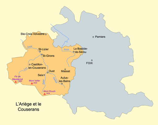
| The Couserans regions is a country of mountains, hills, valleys, meadows and forests, of rivers, lakes, ponds and waterfalls. It is made up of a series of valleys, all converging toward St Girons, opened on the North on Salat river basin. The piedmont is predominantly agricultural, with forests on the hills. It is surrounded mountains. Set at an altitude between 300 and 2,000 meters, the 18-valley Couserans is dominated by Mount Valier (2,838 m). It is closed on the South by the Spanish border mountains (from Peak Crabère to Peak Montcalm); it is limited on the East by the Mas d'Azil cave gate and the Col del Bouich leading to Foix; it is bounded on the West by the Comminges region; and it is at last opened on the North by the Salat basin. The Haut-Couserans mountain area, is made up of 2 river basins, the Castillonais basin (bisected by the Lez river, a major tributary of Salat river, characterized by its closed and narrowed valleys, such as the Biros, Bethmale, Bellongue and Balaguères valleys) and Haut-Salat basin (with the Salat river, and mostly more opened and larger valleys). The Bas-Couserans is found around the Salat river downstream of St Girons. The holiday cottage "Le Jardin de Marie" is located in the Haut-Couserans, Castillonnais basin, a few kilometers north of the town of Castillon-en-Couserans | |
A few words history | |
| The Couserans has been inhabited for thousands of years. This is proved by the archaeological evidence dating back to Magdalenian area (between 17,000 and 10,000 BC). Greek Phocean, then Phoenician settlers were first to explore the region, attracted by gold dust found in the river beds and by the pine resin. Couserans became part of the Roman Empire in 121 BC. The name "Couserans" originates in "Consorani", a city built on a hill overlooking the Salat river and probably founded at the time when the nearby town of St Bertrand de Comminges was built by Pompé in 72 BC. The Couserans was converted to Christianity in 4th Century CE by Valerius - whose name was given to the highest mountain of the region, the Mount Valier. Around that time, the Pyrenean piedmont was invaded by the Visigoths coming from the North, and by Saracens coming from the South. The city of Consorani is renamed St Lizier in the 6th Century CE to commemorate one of its well-known defenders, the bishop Licerius. In 1012, the Earl of Foix decides to be called Earl of Couserans, but the bishopric successfully preserves its territory. The Couserans went through the troubled Cathar period in the 13th century (205 Cathars were burned at the nearby Montségur castle), survived the Wars of Religion in 17th century (pillaging of the city of Pamiers by Henri II de Bourbon-Condé) and finally became part of the Ariège department on the 4th March 1790. At the beginning of the industrial revolution, early 19th century, the coal wooding associated with a forestry code update raise the damselflies war in the Castillonnais region between the springs 1829 and 1830. Dressed as women, the revolted inhabitants will extend that ''jacquerie'' in the Ariège. The industrial revolution has been promoted also because of iron (at Riancé), by so many rivers and forests of the region... and permitted to construct the Montgaillard and Niaux forges, the Tarascon's blast furnaces and Pamiers metal factory. At last, zinc and tungsten ore (Salau area near the border) will also be exploited. A recent project concerns the possible reopening of the Salau's mine. Definitively, remains of mining activities witness of such activity in all the Couserans region. The pulp and paper manufacturing still exist today even if strongly reduced. Until 1942 November 11th, the Ariège was a part of the unoccupied zone in France. Starting in 1942 June, the French underground manifests by its fight against the STO (98% of non-respondents at the end of 1943) and by strong punitive measures pursued by the occupants (the Rimont martyr village). The mountains will be an escape path to Spain (via the Valier's valley). The war achieved with the Castel-Durban liberation on 1944 August 22th. |
| For all information or any bugs, please send a mail to the webmaster here webmaster |


